

|
BOTHELL, WA. – BaseMap announces updates to enhance outdoor planning, research and navigation. Effective immediately for all BaseMap Pro users are two new features designed to facilitate detailed planning for that next outdoor adventure.
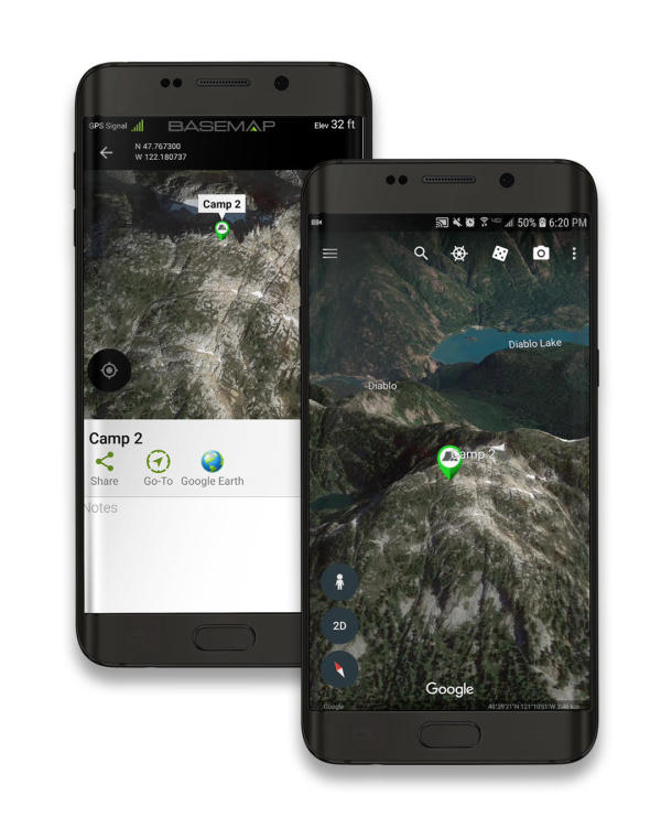
Google Satellite imagery and Google Earth 3D topography have set the standard of modern mapmaking. BaseMap uses Google satellite imagery as its standard and now Pro subscribers have the luxury of opening custom location markers directly from BaseMap to Google Earth with the tap of a button. Custom marker icons and names appear directly on Google Earth giving users quick access and integration to true 3D topographic maps. Simply press the back button on Android or the top left of the screen on IOS to return to BaseMap.
To ease the search for previously marked locations or estimate the distance to a new planned route the Go-To navigation button instantaneously creates a straight line with distance and cardinal direction from the user’s phone to the marker location.
Both new features can be found on any custom marker’s menu in BaseMap. Tap on the “Add Marker” icon to create a custom marker.
It is critical for today’s hunters and outdoor enthusiasts to know their location when afield. BaseMap’s many layers give multiple options for planning and navigation to safely trek elements.
For maximum performance, the $29.99/year BaseMap Pro upgrade includes nationwide Parcel Boundary and Parcel Ownership information, for both private and government ownership, to aid in planning and execution of outdoor activities. For more detailed hunting data, the $9.99 BaseMap Pro Hunt Research upgrade provides hunting information such as unit boundaries, season dates, harvest success, species range maps, watering sources and Boone and Crockett records.
Not a member of the BaseMap family? BaseMap is available on iOS and Android platforms, and on the BaseMap web app (app.basemap.com). BaseMap.com features tutorial videos and information on specific individual outdoor activities.
For iOS download from the App Store click here.
For Android download from Google Play click here.
For download from the Web App click here.
BaseMap offers a comprehensive mapping solution for all outdoorsmen and women providing more than 700 layers of detailed mapping information from private and public land boundaries, when and where to hunt, fishing access, hiking trails, 4x4 routes, wildfire information and much more to help plan the next hunt, fishing trip or backcountry adventure.
Follow BaseMap on Facebook, Instagram and YouTube.
About BaseMap
BaseMap originally came onto the scene in April of 2016 and offered a mapping and hunt planning application that was user friendly and ahead of its time. With years of dedication and attention to detail, the re-launch of this exciting brand is giving outdoorsmen and women exactly what they need. This is a way for everyone to have an affordable tool that will be essential to every step of every outdoor adventure. The updated product features nationwide coverage with hundreds of layers including nationwide private parcel names and boundaries, nationwide lakes and rivers, habitat range information, hiking trails and much more. BaseMap’s vision is to empower everyone to Own The Outdoors.
Contact: Jordan Egli
Blue Heron Communications
(405) 364-3433